When air masses of different densities collide with one another, a boundary is formed between the air masses. Such a boundary is known as a front. A front is produced because of density differences between the air masses; cold air is much denser than warm air. A collision between a warm air mass and a cold air mass will, therefore, result in the less dense warm air rising up and sloping over the denser, colder air. Clouds and precipitation often result as the rising air mass cools.
Fronts are usually classified according to the relative temperature of the advancing air mass. Scientists have identified four types of fronts.
| Name of Front | Formation of Front | Weather Map Symbol |
| cold front | a cold, dense air mass overtakes a warm air mass |  |
| warm front | a lighter, warmer air mass overtakes a denser, colder air mass |  |
| stationary front | air masses move parallel to one another; the boundary between the air masses does not move | 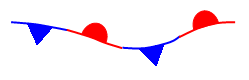 |
| occluded front | a fast moving cold front overtakes a warm front |  |
 Cold and warm fronts are formed by the collision between cold and warm air masses.
Looking at Weather Fronts
Cold Front
- Click here to see the location of a cold front in the eastern U.S. on April 16, 2012.
- Click here to see the cloud patterns for this date.
- Does there appear to be a link between the cloud pattern and the location of the cold front? There appears to be a clear link between the cold front and the cloud pattern since they both occupy the same physical location.
- Check your answer to question 1 by clicking here and superimposing the cold front on the cloud pattern.
- Was your answer to question 1 correct? Explain. Yes, my answer to question 1 was correct. The cold front and the cloud layer fall on exactly the same path.
Cold fronts often result in large often violent storm systems. The cloud data for April 16, 2012 clearly shows the unsettled cloudy conditions associated with this large cold front.
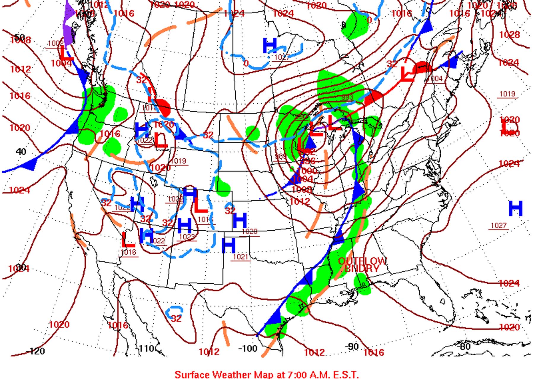 Here is the complete set of surface conditions for North America for April 16, 2012.
Stationary Front
Stationary fronts, on the other hand, can exhibit a wide variety of weather conditions.
- Click here to see the location of two stationary fronts in North America on June 7, 2012.
- Click here to see the cloud patterns for this date.
- Click here to superimpose the stationary fronts on the cloud patterns.
- Describe the sky conditions for the stationary front:
- below Hudson Bay The sky below Hudson Bay is intermittently clear with several partially clouded areas in the stationary front.
- along the southern U.S. The stationary front in the southern U.S. is clear in the west, becomes partly clouded further east, but then gets completely clouded over in the eastern section near Florida.
- Do the sky conditions along these stationary fronts exhibit “a wide variety of weather conditions”? Explain. Yes, the sky conditions in these stationary fronts certainly do exhibit a wide variety of weather conditions. The sky in various areas runs the complete spectrum from completely clear, to partially clouded, and then to completely clouded over.
The Human Touch
Weather maps today are automatically produced by computers. Identifying weather fronts, however, can sometimes be quite difficult. As a result, the plotting of weather fronts is still done by hand.